Property Record
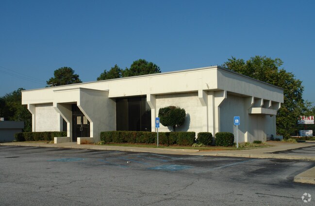
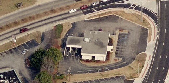
2533 Wesley Chapel Rd, Decatur, GA 30035


Property Detail
2533 Wesley Chapel Rd
15-126-02-001
TRACT 08-JUN-06 .063AC 128 X 13 X 64 X 97 X 182 X 93 X 85 TRACT 09-OCT-06 .063AC 128 X 13 X 64 X 97 X 182 X 93 X 85
Restaurantdrivein
DeKalb
C1
Georgia
B and X Area of moderate flood hazard, usually the area between the limits of the 100-year and 500-year floods.
1
2025
0.63 AC
2025
Forest Park/Morrow
023507
Atlanta
2,750 SF
Atlanta-Sandy Springs-Roswell, GA
NEARBY LISTINGS FOR SALE OR LEASE
DEMOGRAPHICS near 2533 Wesley Chapel Rd
1 mile
3 mile
5 mile
2025 Total Population
9,136
78,970
226,069
2030 Population
9,204
79,933
229,467
Pop Growth 2025-2030
+ 0.74%
+ 1.22%
+ 1.50%
Average Age
41
41
40
2025 Total Households
3,310
29,830
85,161
HH Growth 2025-2030
+ 0.60%
+ 1.17%
+ 1.52%
Median Household Inc
$71,417
$67,265
$66,792
Avg Household Size
2.60
2.60
2.60
2025 Avg HH Vehicles
2.00
2.00
2.00
Median Home Value
$252,429
$263,642
$272,063
Median Year Built
1978
1979
1982
Nearby Places
Map Layers
Map Styles
 Street
 Aerial
Transit
 Traffic
 Biking
Places
Listings with unknown addresses are not visible on the map
- Restaurants
- Banks
- Shops
- Fitness
- Groceries
PUBLIC TRANSPORTATION
AIRPORT
Hartsfield - Jackson Atlanta International
Drive
Walk
Distance
Hartsfield - Jackson Atlanta International
23 min
15.0 mi
Nearby Properties
Address
Land Use
TOTAL SIZE
Lot Size
Zoning
Address
Land Use
TOTAL SIZE
Lot Size
Zoning
988,394 SF
102.84 AC
RM100
Address
Land Use
TOTAL SIZE
Lot Size
Zoning
834,629 SF
59.49 AC
RM100
Address
Land Use
TOTAL SIZE
Lot Size
Zoning
317,008 SF
37.05 AC
RM100
Address
Land Use
TOTAL SIZE
Lot Size
Zoning
250,496 SF
14.35 AC
OI
Address
Land Use
TOTAL SIZE
Lot Size
Zoning
284,650 SF
21.75 AC
R100
Address
Land Use
TOTAL SIZE
Lot Size
Zoning
522,850 SF
41.34 AC
RM75
Address
Land Use
TOTAL SIZE
Lot Size
Zoning
72,870 SF
12.34 AC
C2
Address
Land Use
TOTAL SIZE
Lot Size
Zoning
71,208 SF
15 AC
X
Address
Land Use
TOTAL SIZE
Lot Size
Zoning
292,395 SF
19.65 AC
RM100
Address
Land Use
TOTAL SIZE
Lot Size
Zoning
253,740 SF
13.33 AC
RM75
Address
Land Use
TOTAL SIZE
Lot Size
Zoning
158,939 SF
14.09 AC
RM85
Address
Land Use
TOTAL SIZE
Lot Size
Zoning
13,114 SF
17.54 AC
RM100
Address
Land Use
TOTAL SIZE
Lot Size
Zoning
256,445 SF
11.71 AC
RM85
Address
Land Use
TOTAL SIZE
Lot Size
Zoning
209,022 SF
16.22 AC
RM100
Address
Land Use
TOTAL SIZE
Lot Size
Zoning
814,943 SF
40.83 AC
M
Address
Land Use
TOTAL SIZE
Lot Size
Zoning
249,668 SF
16.76 AC
RM100
Address
Land Use
TOTAL SIZE
Lot Size
Zoning
235,787 SF
15.43 AC
RM100
Address
Land Use
TOTAL SIZE
Lot Size
Zoning
221,594 SF
15.90 AC
RM85
Address
Land Use
TOTAL SIZE
Lot Size
Zoning
174,027 SF
35.37 AC
R100
Address
Land Use
TOTAL SIZE
Lot Size
Zoning
419,434 SF
21.59 AC
RM85
Address
Land Use
TOTAL SIZE
Lot Size
Zoning
23,072 SF
5.48 AC
C1
Address
Land Use
TOTAL SIZE
Lot Size
Zoning
300,697 SF
21.18 AC
RM85
Address
Land Use
TOTAL SIZE
Lot Size
Zoning
132,604 SF
19.12 AC
RM100
Address
Land Use
TOTAL SIZE
Lot Size
Zoning
277,816 SF
18.15 AC
RM100
Address
Land Use
TOTAL SIZE
Lot Size
Zoning
217,904 SF
14.84 AC
Address
Land Use
TOTAL SIZE
Lot Size
Zoning
278,272 SF
21 AC
RM100
Address
Land Use
TOTAL SIZE
Lot Size
Zoning
182,490 SF
12.46 AC
RM100
Address
Land Use
TOTAL SIZE
Lot Size
Zoning
168,610 SF
19 AC
M
Address
Land Use
TOTAL SIZE
Lot Size
Zoning
372,399 SF
12.63 AC
M
Address
Land Use
TOTAL SIZE
Lot Size
Zoning
83,910 SF
10.90 AC
RCH
The World's #1 Commercial Real Estate Marketplace
Connect with us
© 2026 CoStar Group
The information above has been obtained from sources believed reliable. While we do not doubt its accuracy we have not verified it and make no guarantee, warranty or representation about it. It is your responsibility to independently confirm its accuracy and completeness. Any projections, opinions, assumptions, or estimates used are for example only and do not represent the current or future performance of the property. The value of this transaction to you depends on tax and other factors which should be evaluated by your tax, financial, and legal advisors. You and your advisors should conduct a careful, independent investigation of the property to determine to your satisfaction the suitability of the property for your needs.